Your current location: home > Exhibition Hall Online Venue Layout N6 China Aerospace Science and In...
5G Integrated Base Station
Aerospace Xintong Technology Co., Ltd. focuses on military network communication, dedicated network communication, and public network communication. It vigorously develops core network, bearer network, access network basic technologies, and key products. The company has national "Ten Thousand Talents Program" leading talents in scientific and technological innovation, experts in the Broadband Communication and New Network field of the Ministry of Science and Technology, consulting experts in Network Communication Technology field of the Ministry of Industry and Information Technology, outstanding scientific and technological workers of the Chinese Institute of Electronics, and talents in the Chongqing Talent Program. The 5G integrated base station has the characteristics of small size, low power consumption, and convenient installation and commissioning. It supports both STN and PON feedback and supports device cascading, making it particularly suitable for outdoor coverage in rural hotspot areas. Main technical indicators: • Peak power less than 420W; • Weight of the whole machine less than 18kg; • FDD, TDD operator frequency bands; • Transmit power of 2×40W; • Supports channel bandwidth of 20M and 40M; • Downlink peak of >410Mbps; • Uplink peak of >410Mbps; It has obtained 7 invention patents, and representative invention patents are as follows: A method for calculating time deviation in an OFDM system based on cyclic prefix +202211001181.0; A fast AMC method for multi-track system +202211236631.4; A 5G integrated base station and its testing method +202211711959.7. 1. The Aerospace Xintong 5G integrated base station has been deployed in the rural coverage of Chongqing Telecom and deployed in multiple provincial telecom companies, providing support for the comprehensive promotion of rural revitalization and digital rural construction, and supporting China Telecom in completing the construction of "dual gigabit" networks faster and better. 2. In 2022, the 2.1GHz 5G high-power pico base station R&D demonstration project completed trial commercial deployments in 12 districts and counties including Wanzhou, Yunyang, and Liangping in Chongqing Telecom, verifying small-scale networking functions, comprehensive efficiency, and coordination with the macro network. It explored low-cost models for rural and indoor 5G coverage, reduced the construction cost of 5G networks, and achieved customer satisfaction. 3. In 2023, the 2.1GHz 5G high-power integrated pico base station procurement project completed commercial deployments in two districts and counties, such as Bishan and Tongliang, in Chongqing Telecom. It achieved low-cost model networking for rural and indoor 5G coverage, empowering rural revitalization, and customer satisfaction.
Optoelectronic Pod 1
The Beijing Remote Sensing Equipment Institute was established in 1965. It is a key research institute in the field of precision guidance in China and serves as the key laboratory for millimeter-wave remote sensing technology. The institute is primarily engaged in the research and development of high-tech core technologies and equipment in precise measurement and guidance, satellite guidance, and space detection. It combines the research and development capabilities of electricity, optics, and mechanics. The series of optoelectronic pods developed by the Beijing Remote Sensing Equipment Institute can be used for long-range reconnaissance of unmanned aerial vehicles, with capabilities for high-definition visible light, infrared imaging, and laser ranging. It can achieve continuous reconnaissance day and night and, combined with intelligent recognition algorithms, can provide reconnaissance, surveillance, identification, and tracking capabilities for ground and low-altitude targets. It is suitable for real-time aerial monitoring, aerial inspections, and can simulate intelligent recognition, tracking, and positioning of key areas and targets. In response to the demand in the civilian market, the institute has focused on the development of airborne optoelectronic pods and has made breakthroughs in intelligent target recognition and tracking technology, with a focus on addressing the real-time monitoring of key targets and areas in the air. It has been applied in fields such as security monitoring and regional inspections and has collaborated with key clients such as Hiwing Aviation, 365, and Zongheng.
Detection and Warning System
Aerospace Science and Industry Corporation Inertia Technology Co., Ltd. (ASIT) is one of the first batch of key military-civilian conversion enterprises in Beijing. It is mainly engaged in the research, development, production, and service of inertial sensors, safety monitoring and early warning systems, special power circuits, and specialized testing equipment. It has won 11 national scientific and technological progress awards and 19 provincial and ministerial-level scientific and technological progress awards. It has obtained more than 140 national patents and defense patents. Its products are widely used in industries such as aviation, aerospace, weapons, ships, geology, transportation, water conservancy, mining, and petroleum. The intelligent geological disaster monitoring and early warning system is widely used in the fields of geology, transportation, water conservancy, and mining. It has covered 17 provinces and more than 3,000 geological disaster hidden danger points in China. It has successfully issued warnings for nearly 100 geological disasters in Fujian, Hubei, Chongqing, Guizhou, Gansu, Beijing, and other places, building a safety barrier for people's lives and properties.
Radio Frequency Chip
The Beijing Remote Sensing Equipment Institute was established in 1965. It is a key research institute in the field of precision guidance in China and serves as the key laboratory for millimeter-wave remote sensing technology. The institute is primarily engaged in the research and development of high-tech core technologies and equipment in precise measurement and guidance, satellite guidance, and space detection. It combines the research and development capabilities of electricity, optics, and mechanics. With a focus on radar and communication fields, the institute has developed a series of wideband frequency source chips, RF transceiver chips, and digital chips, achieving mass production of multiple chips with independent intellectual property rights. The wideband frequency source chips are designed for applications such as microwave/millimeter-wave radar and communication, using CMOS process and forward design to achieve high-performance frequency source signal output, covering most modules, and achieving hertz-level frequency stepping. These products have been tested or used in more than 300 domestic units. The RF transceiver chips are designed for applications in microwave/millimeter-wave radar and communication. In the field of unmanned aerial vehicles, the institute has developed obstacle avoidance radar phased array transmission chips based on silicon-based processes, focusing on solving obstacle avoidance issues for UAVs. In the field of satellite communication, the Institute has developed satellite communication phased array receiving chips based on silicon-based processes, focusing on addressing issues such as low-orbit broadband satellite communication and high-throughput satellite communication. The digital phased array wave control chip is used to control the phased array RF transceiver chips. It calculates the phase/amplitude of each TR chip of the phased array antenna based on user input angle instructions and can be applied in various industrial control fields. The institute has obtained 31 invention patents, including representative ones such as a dual-mode RF transceiver switch (CN112311418A), a chip automatic encoding device and method (CN112287409A), a gate-controlled clock circuit (CN112311385A), and an ultra-wideband digital control phase shifting device and phase control method (CN22360689A).
Small-Scale Edge Intelligent Controller
Xi'an Aerospace Automation Co., Ltd. is a national high-tech enterprise dedicated to providing intelligent solutions and services to customers using information technology and automation products. In the fields of "smart business, intelligent manufacturing, and military industry", it provides more than 6,000 sets of automation and intelligent overall solutions to industry users. Its performance covers 31 provinces, autonomous regions, and more than 20 countries and regions, making it a well-known provider of industrial automation and intelligent solutions in China. The small-scale edge intelligent controller uses high-performance microcontrollers (based on CORTEX-M4, CORTEX-A7, domestic MCU, and other cores) as the main controller. The product supports communication interfaces such as Ethernet, RS485, RS232, CAN, and protocols such as MODBUS RTU, MODBUS TCP, and CAN Open. It supports 5G remote firmware upgrade and edge computing. The intelligent air valve controller is a series product of the small-scale edge intelligent controller, mainly used in rail transportation, smart buildings, intelligent fire protection, and other fields. It is used in conjunction with PLCs, air valve electric actuators, fans, and other equipment to solve the air circulation problems in enclosed spaces, maximizing the prevention of emergencies such as fires and hypoxia. It has been applied in the Lanzhou Metro Line 2 project and the Tianjin Metro Line 7 project. It has obtained 5 invention patents, and representative invention patents are as follows: 1. Intelligent Controller (ZL202230086323.2) 2. Edge Intelligent Controller (202320737067.8) 3. Edge Intelligent Control System and Method (202310356735.7)
Spectral Imaging
Tianjin Jinhang Technology Physics Research Institute was founded in 1956 and is one of the earliest units in China engaged in the research, development, and production of infrared and laser technology engineering applications. It focuses on nine major professional directions: infrared/visible light detection system technology, laser detection system technology, optoelectronic composite detection system technology, optical design and manufacturing technology, intelligent information processing technology, servo control technology, optoelectronic sensor technology, structure and environmental technology, and electronic and electrical technology. It has developed a wide range of products with leading domestic technological levels that are widely used in national livelihood fields based on the two industrial directions of photoelectric sensors and application systems and intelligent equipment. Hyperspectral imaging system (HSI) can obtain three-dimensional spectral images with the characteristics of "combined spectrum and image" composed of two-dimensional spatial image information and one-dimensional spectral information. It can observe both spatial information and spectral information at each point. The spatial information reflects the external characteristics of size, shape, and defects of the target, while the spectral information reflects the physical and chemical composition of the target. This product utilizes advanced semiconductor process technology to directly integrate the traditional spectrometer system onto the optoelectronic sensor, forming a spectrally imaging microsystem that combines the spectrometer system, optoelectronic detection system, and circuit readout system into one. 1. The advantages of the spectral imaging microsystem compared to traditional technology are as follows: 2. Based on CMOS process technology, it is compatible with sensor manufacturing processes and has cost advantages in mass production. 3. Due to close integration, it reduces stray light and improves photon utilization efficiency. 4. The size and weight are no different from ordinary RGB chips, achieving a finger-sized imaging system. 5. CMOS technology brings unparalleled integration to the system, allowing for high integration with any circuit. Currently, this product can be widely used in fields such as smart agriculture, environmental protection, national defense security, and food and drug testing. The Institute has obtained 6 invention patents, and presentative invention patents are as follows: 1. Gaze-type spectral chip structure for green vegetation detection and preparation method (ZL201910220618.1) 2. Semiconductor process compatible wide-spectrum imaging chip design method (ZL201910184639.2) 3. Wide-tuning range spectral imaging sensor (ZL201811299568.2) 4. Spectral demodulation system and method based on mobile device screen light source (ZL201811299579.0) 5. Spectral data calibration method for single-chip integrated spectral imaging microsystem (Publication No.: CN111024229A) 6. High-pass and low-pass distributed single-band integrated spectral imaging chip structure (Publication No.: CN111024230A).
Case presentation

1. Beijing-Tianjin-Hebei Collaborative Development Transportation Network Geological Safety Monitoring Project 
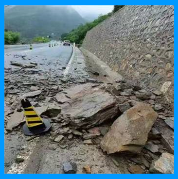
The Beijing-Tianjin-Hebei Collaborative Development Transportation Network Geological Safety Monitoring Project was completed in June 2020. On July 12, 2021, the monitoring data of the Fozizhuang Station on National Highway 108 in Fangshan, Beijing, showed continuous changes, and the monitoring platform issued an early warning. On July 22, 2021, at around 12:00, the rock mass cracked and collapsed. On August 19 and September 14, the disaster site experienced two consecutive collapses. Due to timely monitoring and early warning, the transportation department took timely road control measures to ensure the safety of vehicles passing through, and no casualties were reported. This case was selected as one of the top ten successful cases of geological disaster risk avoidance in China by the Ministry of Natural Resources in 2021.

2.Shiyan Geological Disaster Monitoring Demonstration Project 
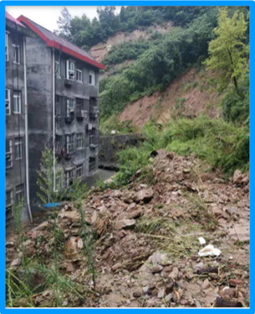
The Shiyan Geological Disaster Monitoring Demonstration Project was completed in July 2019. From the evening of August 5 to the morning of August 6, 2019, Shiyan City experienced heavy rainfall, leading to landslide deformation in the Xingfu Community of Zhangwan District, Shiyan City. At 6:38 am on August 6, the monitoring platform started issuing alarms and continued to do so 15 times within two hours. Local personnel quickly arrived at the scene, confirmed the landslide deformation, and urgently evacuated local residents. The landslide occurred ten minutes after the residents were evacuated, but no casualties were reported. This case received special coverage from media outlets such as People's Daily, CCTV, and Science and Technology Daily, causing strong reactions within the industry.

3. Ceheng "5.28" Yangba Village Landslide Project in Guizhou 
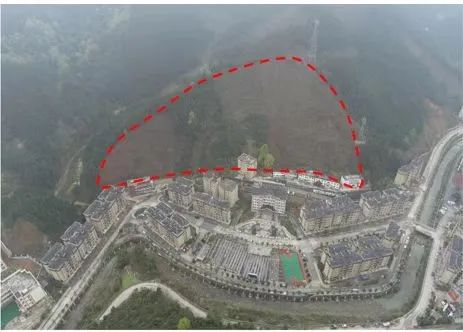
Due to continuous rainfall in the area, at 8:15 am on May 28, 2022, the aerospace inertial GNSS monitoring station deployed at a risk slope disaster hidden danger point in Yangba Village, Ceheng County, Qiannan Prefecture, Guizhou, issued a red warning to the command center. Upon receiving the warning information, the Guizhou Geological Disaster Prevention and Control Center responded promptly, and the Ceheng County Natural Resources Bureau and relevant technical units arrived at the disaster site at 8:34 am to investigate the dangerous situation and set up a warning line, organizing the orderly evacuation of threatened personnel. This landslide caused the destruction of houses on the side of the mountain and damage to five office buildings, but due to accurate warnings and timely on-site disposal, no casualties were reported. This case was selected as one of the top ten successful cases of geological disaster risk avoidance in China by the Ministry of Natural Resources in 2022.